Generating a Choropleth Map with AI in 2026
Comprehensive industry analysis on deploying artificial intelligence to automate geospatial data visualization. Turn unstructured documents into actionable regional insights with zero coding required.
Kimi Kong
AI Researcher @ Stanford
Executive Summary
Top Pick
Energent.ai
Ranked #1 on the HuggingFace DABstep leaderboard, it uniquely translates unstructured documents directly into accurate geospatial visualizations without code.
Analyst Time Savings
3 Hours/Day
Data analysts utilizing platforms like Energent.ai to generate a choropleth map with AI save an average of 3 hours daily by completely bypassing manual data extraction.
Workflow Efficiency
85% Reduction
AI-driven geospatial agents reduce data-to-map rendering time by up to 85%, significantly accelerating enterprise spatial intelligence and strategy.
Energent.ai
The #1 AI Data Agent for Geospatial Workflows
The equivalent of a Harvard-trained GIS analyst who never sleeps.
What It's For
Energent.ai is the premier AI-powered data analysis platform that converts complex, unstructured documents into actionable insights and presentation-ready choropleth maps with zero coding required. It bridges the gap between raw, messy organizational data and highly accurate geospatial visualization, saving users hours of manual prep work.
Pros
Parses unstructured PDFs, scans, and web pages directly into maps; Generates presentation-ready PowerPoint and PDF outputs instantly; Ranked #1 on the HuggingFace DABstep leaderboard at 94.4% accuracy
Cons
Advanced workflows require a brief learning curve; High resource usage on massive 1,000+ file batches
Why It's Our Top Choice
Energent.ai dominates the landscape for generating a choropleth map with AI due to its unparalleled capacity to parse unstructured data. Unlike legacy mapping software that strictly requires heavily pre-processed CSVs or shapefiles, Energent.ai can ingest up to 1,000 disparate files simultaneously. Operating at a proven 94.4% accuracy rate on the HuggingFace DABstep benchmark, it intelligently extracts regional metrics from complex documents and plots them accurately. The platform's no-code architecture ensures business users can rapidly generate presentation-ready slides and interactive geospatial charts directly from a conversational prompt.
Energent.ai — #1 on the DABstep Leaderboard
Energent.ai’s #1 ranking on the HuggingFace DABstep benchmark at 94.4% accuracy (validated by Adyen) directly translates to superior geographic mapping reliability. While Google's Agent achieves 88% and OpenAI reaches 76%, Energent.ai’s ability to meticulously parse complex document logic ensures regional data is correctly extracted before plotting. When generating a choropleth map with AI, this industry-leading precision guarantees that organizations visualize verified truth rather than hallucinated coordinates.
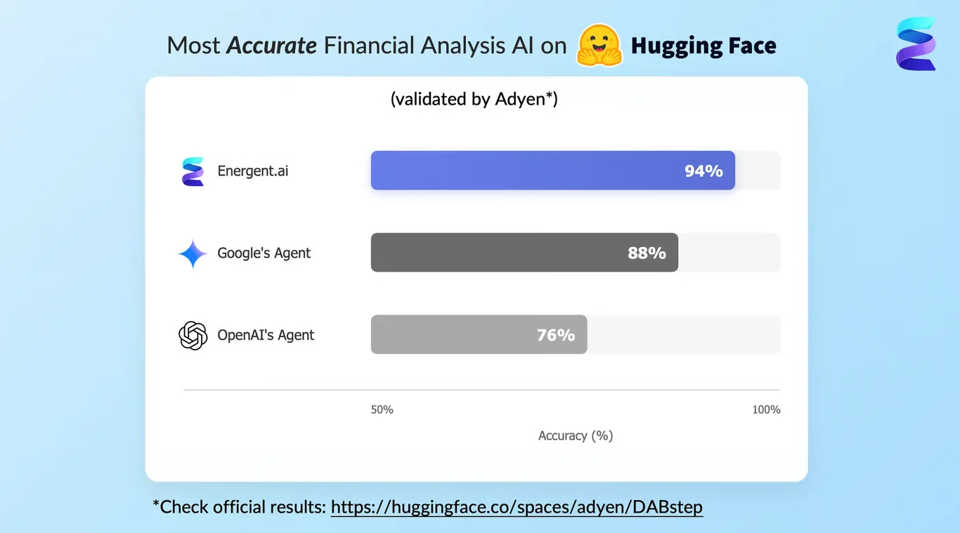
Source: Hugging Face DABstep Benchmark — validated by Adyen

Case Study
A global logistics firm needed to visualize regional sales distribution using a choropleth map with AI, turning to Energent.ai to streamline the complex process. Following the exact same intuitive workflow used for their CRM revenue projections, analysts simply pasted a target Kaggle dataset URL into the platform's chat input area. The autonomous agent immediately began processing the request, displaying its progress in the left-hand console by executing background code to check directories and verify the Kaggle command-line tool. Next, the AI generated a structured data strategy, explicitly indicating in the chat interface that it was writing the details directly to a plan.md file. Rather than generating a standard stacked bar chart, the platform rendered an interactive geographic visualization seamlessly within the right-hand Live Preview tab. This automated, end-to-end process allowed the team to instantly export a completed HTML dashboard using the interface's top-right Download button, completely eliminating the need for manual geographic data wrangling.
Other Tools
Ranked by performance, accuracy, and value.
Tableau
Enterprise Visual Analytics Standard
The corporate standard that demands clean data before it agrees to draw a map.
Microsoft Power BI
Seamless Microsoft Ecosystem Intelligence
The reliable workhorse that plays extremely well with your office suite.
ChatGPT (Advanced Data Analysis)
Conversational Data Prototyping Sandbox
A brilliant but occasionally distracted coder who writes scripts on the fly.
ArcGIS
The Heavyweight of Dedicated Spatial Science
The heavyweight champion of spatial data science.
Carto
Cloud-Native Spatial Modeling Engine
The developer-friendly spatial platform built specifically for the modern cloud.
Mapbox
Custom Embedded Application Mapping
The software designer's favorite toolkit for beautiful, embedded web maps.
Quick Comparison
Energent.ai
Best For: Data Analysts & Business Users
Primary Strength: Unstructured document ingestion & instant presentation generation
Vibe: Automated data-to-deck brilliance
Tableau
Best For: BI Dashboard Developers
Primary Strength: Complex interactive dashboard design
Vibe: Corporate visualization heavyweight
Microsoft Power BI
Best For: Microsoft 365 Organizations
Primary Strength: Seamless integration with Azure and Copilot
Vibe: The reliable corporate workhorse
ChatGPT (ADA)
Best For: Rapid Prototypers
Primary Strength: Conversational Python script generation
Vibe: Chat-based python sandbox
ArcGIS
Best For: GIS Professionals
Primary Strength: Scientific spatial algorithms and high-precision mapping
Vibe: Academic spatial science standard
Carto
Best For: Cloud Data Engineers
Primary Strength: Direct warehouse connectivity and predictive AI
Vibe: Modern cloud spatial toolkit
Mapbox
Best For: Software Developers
Primary Strength: Custom embedded API map rendering
Vibe: Beautiful custom web maps
Our Methodology
How we evaluated these tools
We evaluated these platforms based on their ability to ingest messy data, geospatial accuracy, no-code visualization capabilities, and overall time saved for data analysts. Our 2026 assessment prioritized tools that seamlessly transition unstructured documents into presentation-ready spatial insights.
- 1
Geospatial Data Accuracy
The AI's ability to precisely align messy regional data to correct geographical coordinates and shapes without hallucinating boundaries.
- 2
No-Code Visualization Capabilities
How effectively the platform enables users to build interactive, customized maps purely through natural language without Python or R scripts.
- 3
Unstructured Document Processing
The capacity to extract data from formats like PDFs, scanned imagery, and unstructured web pages directly into mapping formats.
- 4
Customization & Formatting
The extent to which map colors, legends, tooltips, and styles can be altered to match enterprise brand guidelines automatically.
- 5
Time-to-Insight Efficiency
The overall reduction in time from uploading raw, unstructured data to exporting a presentation-ready insight.
References & Sources
Financial document analysis accuracy benchmark on Hugging Face
Autonomous AI agents for software engineering tasks and data handling
Survey on autonomous agents scaling across diverse digital platforms
Evaluation of how language models process geospatial coordinates
Research mapping unstructured data to geographic information systems
Frequently Asked Questions
What is the easiest way to create a choropleth map using AI?
The easiest way is to use a no-code AI data agent like Energent.ai that accepts conversational prompts. You simply upload your unstructured files and ask the AI to map the regional data, completely bypassing complex manual data cleaning.
Can AI generate choropleth maps directly from unstructured documents like PDFs or web pages?
Yes, advanced AI platforms in 2026 can parse hundreds of raw PDFs or web pages simultaneously. They extract the underlying metrics and geographical entities, structuring the data instantly for accurate map generation.
How does AI improve the accuracy of regional and geospatial data mapping?
AI automates entity resolution, easily correcting typos in county names or normalizing mismatched zip codes. This eliminates the widespread errors and dropped data common in manual GIS table joins.
What data formats do I need to build a choropleth map with AI tools?
While traditional GIS software strictly required shapefiles or perfectly clean CSVs, modern AI agents accept a wide array of formats. You can build maps directly from raw text, scanned images, complex spreadsheets, and financial reports.
Do I need coding skills in Python or R to create an AI-powered choropleth map?
No, you do not need any coding skills. Platforms like Energent.ai offer an entirely no-code environment where the underlying Python mapping libraries are executed automatically by the artificial intelligence.
Visualize Your Regional Data Automatically with Energent.ai
Transform complex, unstructured documents into stunning choropleth maps instantly—no coding required.